OE-spec
Specifications
| SKU | 1380050 |
Fitment
WATERPROOF CHARTS · 1380050
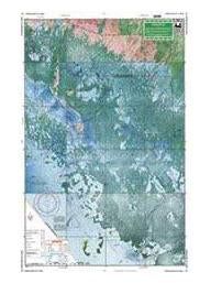
Waterproof Charts 40E Everglades City Area Large Print Navigation
Waterproof Charts 40E Everglades City Area Large Print Navigation Detailed coverage of the 10,000 Islands area from Tripod Key to Chatham Bend. Includes Coon Key, Dismal Key, Port of the Islands and all the waterways south of Route 41. Compiled from NOAA charts and USGS Pictomaps this chart features canoe trails, inside small boat routes, updated beaches and campgrounds, GPS Waypoints and importan
No store near you stocks this yet
This part is in our catalog but no nearby shop carries it right now. Check back soon, or search for a similar part in stock near you.